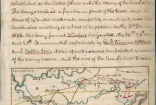
Civil War

Photograph shows view of Knoxville from slope of Fort Dickerson, 1864.
Map of the approaches and defences of Knoxville, Tenn., showing the positions occupied by the United States & Confederate forces during the siege.
Map of Fort Sanders, Knoxville, Tennessee, showing the Confederate assault of Nov. 29, 1863
Assault on Fort Sanders
Photograph shows group portrait of former prisoners of war and guides taken upon their arrival at Knoxville, Tennessee, on January 1, 1865.
This map shows a regional view of north central Tennessee that includes Nashville, Murfreesboro, Knoxville, and Bowling Green.
1 / 6
Photograph shows view of Knoxville from slope of Fort Dickerson, 1864.
Map of the approaches and defences of Knoxville, Tenn., showing the positions occupied by the United States & Confederate forces during the siege.
Map of Fort Sanders, Knoxville, Tennessee, showing the Confederate assault of Nov. 29, 1863
Assault on Fort Sanders
Photograph shows group portrait of former prisoners of war and guides taken upon their arrival at Knoxville, Tennessee, on January 1, 1865.
This map shows a regional view of north central Tennessee that includes Nashville, Murfreesboro, Knoxville, and Bowling Green.